|

GHTC Maintained Trails
See bottom of page on how to access GHTC Online Trail Map and printable PDFs, FREE to GHTC members.
GHTC MAINTAINED TRAILS
GHTC does not own any land. The trails belong to both private and public landowners. They have granted a privilege to the Guelph Hiking Trail Club. In consideration of the landowners’ rights, and as responsible members of the Club, please adhere to the following Trail Users’ Code.
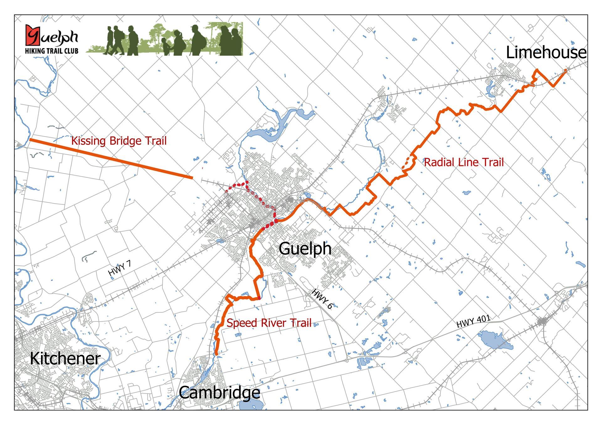
The Guelph Hiking Trail Club has established and maintains three main trails and their related side trails. The total length of these trails is, at present, approximately 80km.
The Radial Line Trail and the Speed River Trail are marked by single orange paint blazes, approximately 15cm high by 5 cm wide, on trees, fence posts, stiles or rocks. Double blazes, one staggered above the other, indicate a change of direction. Side trails are blazed in blue.
The Kissing Bridge Trailway is not blazed, as it follows an abandoned railway line on an obvious course. It is however, very well signed.
Radial Line Trail
- Radial Line Trail-- generally follows an abandoned railway line from the City of Guelph, easterly through the valleys of the Eramosa River, Blue Springs Creek and Black Creek to the Bruce Trail near Limestone. This trail is not suitable for motor vehicles. Some sections of this trail west of Wellington Rd 29 are shared-use with bicycles, by landowner agreement. East of Wellington #29 is pedestrian use only, as the landowners have not sanctioned motorized vehicles or bicycles as uses of the trail. Some sections are suitable for snowshoeing or cross-country skiing depending on snow conditions. Trail length 37.5km
Speed River Trail
Speed River Trail-- begins at the west side of the City of Guelph and follows the Speed River in a southwesterly direction to the edge of Cambridge. This trail is not suitable for bicycles or any other motor vehicles, nor have the landowners sanctioned these as uses of the trail. Some sections are suitable for snowshoeing or cross-country skiing depending on snow conditions. Trail length 14.6km
Kissing Bridge Trailway
Kissing Bridge Trailway-- is
a multipurpose trail, following the former CPR Guelph-to-Goderich
railway line from the northern end of Guelph to Millbank. The Guelph
Hiking Trail Club, maintains the 12 km section from Silvercreek Pkwy N. trailhead
(Wellington Rd 39) in Guelph to Katherine St near West Montrose. This trail is suitable for hiking, biking, snow-shoeing and
skiing. In addition, some sections are open to snowmobiles during the
winter.
Starkey Hill Loop Trail
Starkey Hill Loop Trail--a 3.5 km loop trail southeast of Guelph that is jointly maintained with the Grand River Conservation Authority.
Online Trail MapNow available FREE to members is an online version of GHTC trails that you can access from your mobile device or computer. The map includes a Menu, will list waypoints (green markers), trail segments (orange and blue segment markers), and other highlights such as bridges, parking areas, etc. Clicking on these reveals more information, similar text descriptions as in our hardcopy Handbook 14th Edition, but updated to our current trail locations and status. When you order the online version a link to the trail map will be emailed to you. Save link for future access. Non members cost for online trail map is $5. |
|

Online printable GHTC Trail section PDFsNow available FREE to members are printable PDFs for each GHTC trail section. Each PDF includes a coloured map similar to maps in GHTC handbook, plus a one page text with trail description. Just print PDF and take on trail with you. When you order the online PDFs, a link to all GHTC trail sections will be emailed to you. Save link for future access. Non members cost for all printable PDF sections is $5. |
|
Trail Handbook
TRAIL MAPS Coloured trail maps are published in our 2025 Guelph Hiking Trail Club Handbook.
It is not necessary to be a member to buy a Handbook, but membership fees help us keep these trails open. The cost for handbook is $24 for members and $30 for non-members.
|
|

ACKNOWLEDGEMENTS
The Guelph Hiking Trail Club is wishes to express gratitude and acknowledge:
- The landowners who have kindly granted permission to the Club to establish trails on their properties.
- The small and dedicated group who originally formed the Guelph Hiking Trail Club and worked diligently to clear and blaze the Radial Line Trail; those who carried on and established the Speed River Trail and the Kissing Bridge Trailway; and those members who continue to maintain these trails.
-
The many individuals and organizations who have donated funds which have enabled the Club to make capital improvements to our trails, including the Guelph Lions Club, the TD Canada Trust Friends of the Environment Foundation, the County of Wellington, the Regional Municipality of Waterloo, City of Guelph, City of Cambridge, Halton Hills, Guelph Community Foundation, Gosling Foundation. Federal Government and the Trillium Foundation.
Guelph Hiking Trail Club is a charitable organization Registration#11894 9395 PO Box 1, Guelph, ON, N1H 6J6 |