|

- Home
- Trails
- Year of the Bridges
- Starkey Hill Trail Bridges
Starkey Hill Trail Bridges
By Liam Waterman, GHTC Volunteer
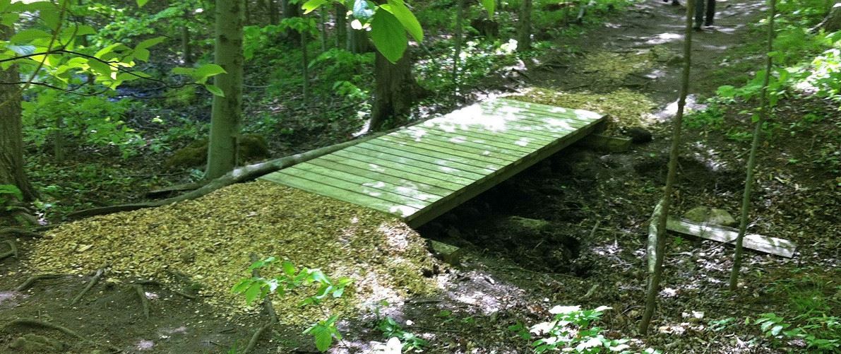
The Starkey Hill trail, despite being one of the first established by the Guelph Hiking Trail Club (GHTC), only received its current group of five bridges a little more than a decade ago. The trail has been jointly managed by the GHTC and the Grand River Conservation Authority (GRCA) since its initial construction in 1973, which occurred only a year after the GRCA purchased the Starkey property in 1972 on behalf of the City of Guelph.1 The bridges themselves were installed beginning in 2012, with a fifth and final bridge constructed in 2013.2 Though simple in design, these bridges play an important role not only in improving the accessibility of the trail, but also in protecting the natural environment of Starkey Hill. By covering over particular wet spots on the trail, these bridges allow users to pass through the property without disturbing either the underlying wetland habitat or the forests surrounding them.
The need for these bridges arises from the particular geography of Starkey Hill. The property is located on the edge of the Paris moraine; a moraine is a kind of geological feature consisting of a large accumulation of mixed debris ranging from larger rocks to finer gravel and sand.3 Water filters into the ground through this porous upper layer, making such moraines valuable for replenishing streams and wetlands, along with the underground aquifers that provide drinking water in the Guelph area.4 The moraine was created by glaciers from the Laurentide ice sheet, which moved across southern Ontario during a period of deglaciation in the early to middle Holocene.5 The summit itself is a drumlin, a kind of elongated hill created by the action of glacial ice on the unconsolidated matter of a moraine. In some locations chunks of ice were deposited alongside the mixed debris of the moraine. Where these chunks melted, depressions called “kettle holes” or sometimes “kettle lakes” were formed.6 Starkey Hill is home to a large number of kettle holes, which collect water to form ponds and wetlands.7 Protecting these water sources was the main motivation for the GRCA to initially purchase the property. Unfortunately, despite their positive role in local water systems, the depressions in the Starkey Hill property can be problematic for hikers when they intersect with the trail. Prior to the bridges, several locations on the Starkey Hill trail could become particularly wet or muddy when water levels were high, an effect which was at its worst during the spring season.
Installing bridges on the trail offered a way for hikers to avoid these seasonal wet areas. Bridge construction was organized by the GRCA in collaboration with Jim Hoare of the GHTC, who was trail captain of the loop and responsible in part for its ongoing maintenance. Martin Neumann, then property manager of Starkey Hill for the GRCA, along with Jim Hoare conducted an inspection of the trail to identify locations that became exceptionally wet in the spring months. Four locations in need of bridges were initially identified. The GRCA received a funding grant for $2000 from TD bank in late 2011, allocated towards dealing with these spots.8 Toyota Motor Manufacturing Canada also supplied additional funds and volunteer support. Neumann’s particular concern was that high moisture areas on the trail might prompt hikers to traverse around the actual maintained trail, thereby possibly disturbing the surrounding forest. The construction of the bridges on the Starkey Hill loop can be considered a component of the GRCA’s conservation effort, working to preserve the health of the property’s forest.
Construction of these initial four bridges occurred during May of 2012. GRCA arborists had been engaged in thinning the forest at Starkey that April, and the wood chips created in that process, rather than being spread on the forest floor as per usual, were saved in a few piles in order to be placed at either ends of the new bridges and to deal with other seasonal wet spots. These four bridges were constructed over the course of two days. On the first day, volunteers from the Toyota Motor Manufacturing plant in Cambridge collaborated with GRCA staff to construct the three smallest of the four bridges. The bridges were designed with a 6 x 6 inch sleeper board on either end, with three 6 x 6 inch stringers laid across. 6 x 2 inch boards were used for decking, which were screwed into the stringers. Jim Hoare and members of GRCA staff were responsible for arranging the layout of the bridges, which meant ensuring that the sleepers were both level and placed correctly. The Toyota volunteers then installed the decking on these bridges. They also brought building materials from the parking lot using wheelbarrows, a difficult task considering the up-and-down nature of the Starkey Hill trail. One 12-foot bridge and two 16-foot bridges were constructed the first day. Turning left on entering at the trailhead, these bridges will be the first, second, and fourth bridges that you encounter on the Starkey Hill Trail. On the second day of construction, GRCA staff put in a fourth bridge, the 32-foot bridge that is currently nearest to the summit. This bridge, also the furthest from the trailhead, was designed to rest on a pipe placed underneath its center, which would both support the bridge and allow water and wetland animals to pass underneath. GRCA staff used an all-terrain vehicle to bring building materials over the summit, a route which was deemed more efficient than following the conventional direction of the trail. Again, woodchips were spread to support either side of the bridge.
Following the installation of these initial four bridges, there were some low wet spots on the trail that remained a point of concern for Neumann and Jim Hoare. Initially they believed that these could be fixed using the remaining woodchips left by GRCA arborists. Unfortunately, spreading woodchips turned out to be ineffective at keeping the trail elevated. Jim tells us: “You walked over them and they just pushed right into the puddle… they didn’t last more than a year.”10 Reusing woodchips from the 2012 forest thinning the following year also turned out to be impossible, as the pile left at Starkey Hill became so overgrown with mold, moss, and other decomposers that it became difficult to separate into individual woodchips. This approach was abandoned. In 2013, Toyota Motor Manufacturing provided funding and volunteers for a fifth bridge, which would deal with one of the remaining wet spots on the trail. This was a 16-foot-long bridge, with the same design as the initial four. This was the conclusion of construction on the Starkey Hill bridges. A signpost has been placed near the first bridge, giving credit to both Toyota Motor Manufacturing Canada and the GRCA for their work on these important connections.
The current five bridges on the Starkey Hill trail have lasted up to the present day with no need for maintenance. Jim Hoare expects that it will be the GHTC undertaking any maintenance on the bridges from this point forward, as the club has formally assumed a much greater responsibility over the trail since the signing of its official agreement with the GRCA in 2012.11 Though these bridges were in large part constructed by individuals and organizations outside of the GHTC itself, they remain a part of its legacy and responsibility. The Starkey Hill bridges are significant structures enhancing one of the GHTC’s most popular side trails, both protecting the natural environment around it and making the trail safer and more enjoyable for all users.
Notes
1. “Starkey Hill Trail”, Guelph Hiking Trail Club, https://guelphhiking.com/starkey.
2. Much of the information in this issue was procured through an in-person interview with Jim Hoare of the GHTC in June 2023. Many thanks to him for his help in this project.
3. Sadura, S., et. al. “Morphology and GPR Stratigraphy of a Frontal Part of an End Moraine of the Laurentide Ice Sheet: Paris Moraine Near Guelph, ON, Canada”, Geomorphology 75, no. 1 (2006): 216, https://doi.org/10.1016/j.geomorph.2005.01.014.
4. “State of the Watershed Report”, Grand River Conservation Authority, 1998, 2.1, https://www.grandriver.ca/en/our-watershed/resources/Documents/Water_History_1998HealthReport.pdf.
5. Ullman, David J., et. al. “Final Laurentide Ice-Sheet Deglaciation and Holocene Climate-Sea Level Change,” Quaternary Science Reviews 152, (2016): 49, https://doi.org/10.1016/j.quascirev.2016.09.014.
6. Campbell, D.R, et. al. “Post-Glacial Development of a Kettle-Hole Peatland in Southern Ontario”, Écoscience 4, no. 3 (1997): 404, https://doi.org/10.1080/11956860.1997.11682419.
7. “Starkey Hill Interpretive Trail Highlights: Kettle Lakes”, Guelph Hiking Trail Club, https://www.guelphhiking.com/starkey/p9.htm.
8. “Starkey Trail Update,” Guelph Hiking Trail Club Newsletter 40, no. 2 (2012): 3, https://issuu.com/doberman_xy/docs/ghtc_40_2.
9. “Starkey Hill Interpretive Trail Highlights: Fast Growing Pine Plantation,” Guelph Hiking Trail Club, https://www.guelphhiking.com/starkey/p10.htm.
10. In discussion with the author, June 2023.
11. “Minutes of the Annual General Meeting - November 15, 2012,” Guelph Hiking Trail Club Newsletter 41, no. 3 (2013): 8, https://issuu.com/doberman_xy/docs/ghtc_41_3.
Guelph Hiking Trail Club is a charitable organization Registration#11894 9395 PO Box 1, Guelph, ON, N1H 6J6 |